I love flying VFR styles and would like to download some free mesh files, which enhance the scenery, in my opinion, way better than anything else. I already have some payware stuff, but was wondering if anyone could link me to what they think is some high quality stuff!
I am looking for some files of the 'Phillapeane Achapelo Islands' which I once saw on the amazing race and they looked awsome 🙂 but anything, anywhere will do!
Cheers!
They have pay-ware also.
http://portal.fsgenesis.net/modules.php?op=modload&name=Downloads&file=index&req=viewdownload&cid=1
Thanks Rman, I thought you would be the one with the links! Now for my second question, which is better: 38.2m Terrain Mesh , 76.4m Terrain Mesh or 9.6m Terrain Mesh?
I'm taking this from a friend of mine who beta tests mesh.
*************
Depending how it's packaged, it will either install as part of a package in the Add-on Scenery folder or just be dropped in the \fs9\Scenery\World\Scenery folder.
Most of the mesh I have is in the latter of the two, as they are more global in scope. My choice for mesh is anything by FSGenesis. All of the US is available for free from spots such as Avsim. Most of the mesh available by FSG and others is what's called LOD 10 mesh, or where the data is interleaved into 38.2 meter data points. There are a very few that are set up to be LOD 11 mesh or data points at 19.6 meters. And there's LOD 12, which has data at 9.6 meters.
Now the only problem with levels above LOD 10 is that supposedly FS 2004 doesn't display it as anything other than LOD 10?!? Unless you patch to v9.1, then you're suppose to get 19.2 or LOD 11 back.
So what happens if you install overlapping mesh with different levels of LOD, FS will take the mesh with the higher LOD and display that. If you have duplicate mesh with the same LOD??? Depends then where the priority level is in the scenery library. The stock M$ is down at the bottom of the list, the stuff I really want to shine is sitting at the top.
********************
So the lower the number in metres, the higher the level of detail?
Sorry, I still dont really get it 😕
As far as I understand it the number of meters is an indication of how far apart the data points are. Remember that the mesh describes the height of the terrain (not what the surface looks like) and each data point is rendered by FS according to the height it specifies. The closer the data points the more detail will be rendered because the FS engine doesn't have to guess as much. If the data points are further apart then FS has to fill in between the data points and you get flattened scenery.
This is fine for fields and rolling hills, but imagine a mountain with smoothed out terrain. Not very interesting. If you move the data points closer together FS is able to accurately render the peaks and valleys and jagged edges, etc.
Of course, more data points mean more data which costs more and takes more effort to gather and compile.
Here's a link to some freeware stuff that covers the whole world with 70m.
http://www.simviation.com/fsdterrainsrtm.htm
I'm not sure of the accuracy of the data or how it compares with other stuff. But, well, it's free.
Thanks for the explanation ShockAndYaw, I now fully understand the Mesh levels of detail!
Also, thanks for the GREAT A+++ link, to otheres reading it, go here: http://www.simviation.com/fsdterrainsrtm.htm It has a map cut up into several hundered sections and you can download individual files of ANY area you want on the planet! Its awsome! Thanks man!
cheekytrolly wrote:
So the lower the number in metres, the higher the level of detail?
Sorry, I still dont really get it 😕
Yeap, thats right. Most of FS is done in about 1,200 meter data, not that good, but as the numbers get smaller, like 10 meter for example, the terrian will get extreamly realistic looking. The lower the number, the better.
Awesome, thanks SamIntel. I downloaded the Philippine mesh I was looking for and it’s much better than Microsoft’s default stuff.
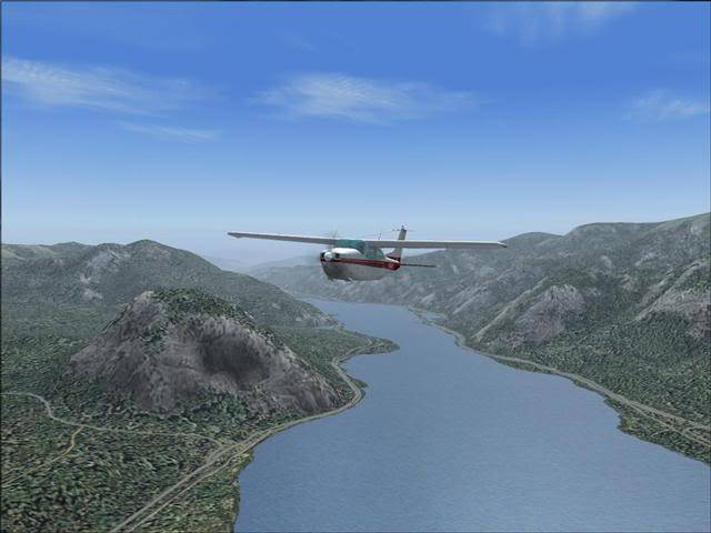
I also found something on avsim which I think is even better than the simviation stuff (both are free) I actually saw it on one of Radarman's links to an inland water update, and downloaded it this morning.
The file name is 'cr_gorge.zip' which stands for the Columbia River Gorge and the 20mb file can be downloaded here: http://library.avsim.net/search.php?SearchTerm=cr_gorge.zip&CatID=root
The blurb says "This package completely replaces approx. 5,000 sq mi of the default landscape of the Columbia River Gorge and adjacent areas of Washington and Oregon. Three volcanic peaks - Mount St. Helens, Mount Adams, and Mount Hood - as well as old lava beds, deep river valleys, many small lakes, and the majestic Columbia River offer great opportunities for scenic and challenging flights. Accurate placement of rivers, lakes, streams, roads, railroads, hydro dams, and power lines, as well as land use textures (land class), water colors (water class) and a high-res terrain mesh. Also added are the massive volcanic blast area of Mount St. Helens and the ski areas at Mt. Hood."
I couldn’t resist at least one screenshot, I hope you all don't mind 😉
And I have plenty more where that came from 😎
I had a cd with Africa terrain mesh for fs2004 but it cracked Is it possible to get it somewhere again?
If the question and answers provided above do not answer your specific question - why not ask a new question of your own? Our community and flight simulator experts will provided a dedicated and unique answer to your flight sim question. And, you don't even need to register to post your question!
Be sure to search for your question from existing posted questions before asking a new question as your question may already exist from another user. If you're sure your question is unique and hasn't been asked before, consider asking a new question.
Flight Sim Questions that are closely related to this...