UPDATE - 19 Mar 08 - Original post updated, to include clarification on certain parts, to add some common questions and answers to those questions and clarification about the GPS approach.
Approaches
- Instrument Landing System (ILS) Guides:
1) If you have filed an IFR flight plan, you will receive mandatory instructions at around 70 miles from your destination airport. Follow these instructions.
...and a clearance from around 25 miles
Follow instructions carefully - try writing them down if you think you'll forget. Write down the airport dictated in that clearance (if you don't already know it) and the runway and type of approach, i.e. ILS (type of instrument approach) 9L (the runway).
2) You then need to go to your Map which is the little star like icon on the panel or go to the "World" menu at the top and click "Map".
Or
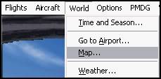
You should see a purple line towards your destination airport from where you are:
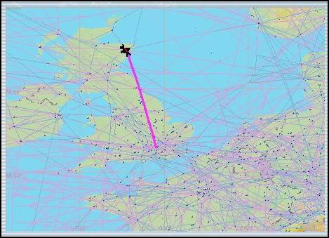
...follow this line to your airport, and double click on a runway at that airport in the map, (Note, you might need to do this more than once, as sometimes it thinks you're trying to change the route).
3) From the map, there should be a list of runways with a line of information after them. Find the runway that you received in your clearance in Point 1. Write down the ILS heading i.e. 093 degrees, and the ILS frequency of that runway (110.30), as well as the Airport Elevation (80ft) which can be found in that same box above the list of runways.
ILS information:
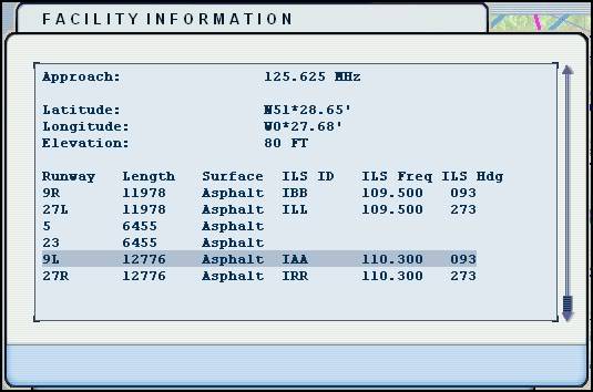
Elevation:
4) After you have all of that information written down, close the map and open your Radio Stack....
Key in the frequency you wrote down using the inner and outer knob, into NAV1 and make sure it is in the primary position, meaning it is on the left as opposed to the right of the two displays. This can be done by pressing the <---> button in the middle of the two screens.
At the bottom of the radio stack, there should be a row of clickable buttons, namely COM1, COM2, BOTH, NAV1, NAV2, MKR, ADF, DME etc. Click the NAV1 button as to illuminate the light. This enables you to hear the morse code frequency to check you have the correct frequency...
Note: MKR, DME and ADF are not essential for an ILS approach.
5) Close the radio stack, and enter the runway heading you wrote down from the map, into the Autopilot panel (MCP), under the CRS section (Course). This will serve to position the ILS raw data display in line with the runway, as you can see in the two diagrams at Point 12.
**In some aircraft such as the 747, the CRS selector is found on the Horizontal Situation Indicator (HSI) which is the compass on the panel, usually found under the Attitude Indicator.**
---You now have the approach set up, and should be flying towards your airport whilst descending. At about 30nm out, you should be around 9000 feet, descending at around 1500-1800 fpm with a speed of roughly 240 KIAS; aiming to reach 2800 feet by 15nm from the airport---
6) Once you reach the height and distance of 2800 feet AGL from 15nm out, you will now be hearing the ILS Morse code identifier and you should be roughly on course, according to the HSI (but only if you have remembered to type the ILS heading into the course selector). If you already have the GPS / NAV switch on NAV, you will soon see the glideslope becoming active - the point at which the bug / indicator starts to move from its bottom most position. You will need to be at a speed of 180 KIAS or less at this point.
7) At this point, or around 10nm out, at the same altitude, you should receive a clearance to land from ATC.
**************From here, you have two options:
- For Autopilot to control the descent on the ILS = Go to point 8
- To hand fly visually on the ILS = Go to point 12
--> For Autopilot to track the ILS...
😎 Switch the GPS / NAV switch to NAV instead of GPS.
9) Make sure you have Autopilot on, your speed is at or below 180 KIAS, and you are at a height of 2800 feet or less. Press the APP button at around 10 nm out, and the aircraft will follow its path down vertically and laterally until you get to 500 feet AGL. Note that you don't need to disengage the altitude hold button if you have it engaged - the AP will do that for you when you engage the APP button.
10) You will have to control flaps, auto brakes, speed and gear on this approach. At 500 feet AGL, you must disengage the Autopilot and hand fly the last 500 feet.
11) Once you land, slow down and taxi from the runway.
--> For manual approach on the ILS...
12) On the attitude indicator on the right and bottom side or similarly on the HSI, white indicator lines shall appear, with a pink triangle on both the vertical and horizontal set of lines. The big line in the middle is the centre of the approach and is the correct glide slope.
If you are too high, the triangle on the vertical axis will be below the middle line and vice versa. If you are too far to the left, the line will appear to the right of the middle bigger line, indicating that you should turn to the right until it centres.
To put it simply, fly towards the lines as to centre them. Other visual forms of interpeting raw data that the ILS provides exists. for example, two moveable bugs on a horizontal and vertical axis. The method remains the same - fly towards the lines, just as you do the triangles:
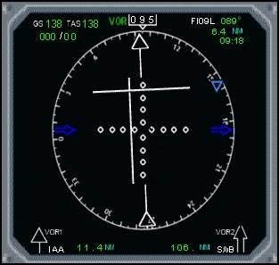
In the above hand-flown example, I am slightly low and slightly too far to the right i.e. I need to maintain altitude for a few seconds and add some left aileron and rudder. It takes practice, but becomes easier after that practice. The result...
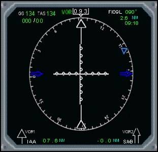
13) Do this all the way down to the runway threshold; making small movements on the control surfaces to centre the arrows / lines on the HSI or attitude indicator. You can use the autothrottle (A/THR) to control the speed if you find this easier. At the same time, you need to control flaps and gear etc.
Common Questions...
1) Why do I have to intercept the glideslope from below?
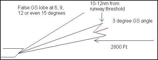
As you can see, the beam of the ILS extends to around 10-12nm. When the aircraft flies towards the runway, they are about to intercept the glideslope beam causing the vertical indicator to show the aircraft is on the correct descent gradient. From this point, the aircraft needs to start descending; below 2800 feet to stay in the centre of the 2 lines, which get closer and closer together until the threshold of the runway.
If you were much higher than this point, you can see that you'd miss the beginning of the GS and possibly encounter False GS Lobes which will provide misleading information.
2) Why when I engage the APP does the aircraft get a mind of its own?
In most cases, this is usually because you are engaging the approach hold button too early, or at too higher speed. You also need to make sure that you are near centered on both axes of the ILS before engaging the APP.
3) Why do I have to wait until the axes are centered before engaging APP?
Simple. The APP function of the autopilot is an approach hold feature. Therefore, it was only ever designed to hold an approach that the pilot has setup. It only follows that it won't do well in trying to track both the localiser and GS from scratch.
4) Can I perform an autoland using the ILS?
No. No default aircraft in FS9 or FSX is capable of landing automatically. The APP is only an approach hold function and must be disengaged along with the A/THR at Decision Height or above. Decision Height is the height above ground level, specified in the approach plate for that runway, that you must commence a go around if you don't have visual contact with the airfield and runway.
5) Why am I having trouble trying to centre the axes?
There is no simple solution to this. Practice in a smaller aircraft first. The example above is using a Boeing 737. Try out an ILS approach in a Cessna to get a feel for how much movement you'll need to stay centered on the approach.
6) Why do I end up 'missing' or 'over-shooting' the glideslope and localiser?
This is most probably down to poor handling of the aircraft or due to flying at too higher speed. Make small movements on the control surfaces and I suggest clearing the weather so you can see the airfield at all times. This will help you gauge how much you'll need to compensate with regards to control surfaces.
7) What is that damn annoying beeping noise when I approach the runway?
It's the morse code identifier for the NAV aid's frequency that you have tuned in NAV1. Cross-checking the morse code you hear with the morse code on the map / chart will confirm you are tracking the desired NAV aid.
😎 Why do I need to turn the NAV/GPS switch to NAV?
The NAV and GPS settings relate to two different entities. Real world aircraft don't use the GPS like the sim does so this switch isn't in existence in the real world. Simply put, the GPS side of the switch simply slaves the autopilot to what is programmed into the GPS. The NAV side of the switch slaves the autopilot and instruments to any NAV aids you have the NAV radios tuned to.
9) At some airports, I've descended to 2800ft but am really close to the ground, or even worse, it is below the level of the ground. What's going on??
This is where the airport elevation part of Point 3 comes in. When descending to an airport of higher elevation than normal, you need to make sure you add the elevation of the airport to 2800ft to give you an interception altitude. In the example above, the airport is at an elevation of 80ft, making little to no difference. However, airports like Denver, Colorado have an elevation of 5000ft - descending to 2800ft AMSL, will leave you 2200ft underground - not a good position. Therefore, adding the airport elevation to 2800ft will make 7800ft, leaving you 2800ft above ground level.
- VHF Omni directional Range (VOR) Approach Guides
Read through the link below...
http://stoenworks.com/Tutorials/IFR,%20VOR%20Approaches.html
Alternatively...
http://www.navfltsm.addr.com/vor-appr.htm
- Non-Directional Beacon NDB (Automatic Direction Finder) ADF Approach Guides
Alternatively...
http://www.navfltsm.addr.com/ndb-appr.htm
- Global Positioning Satellite (GPS) Approach Guide
The GPS approach will allow you to fly towards an airport or runway using the autopilot with NAV engaged and the NAV/GPS switch set to GPS. The tracking is only lateral so descent will have to be controlled by the pilot. Again, autopilot should be disconnected by 200ft AGL.
1) Open up the GPS.
2) Click the button on the right hand side at the top with "--->" on.
3) Click the right arrow on the inner knob on the bottom right hand side of the GPS once and enter the 4 digit ICAO code for the airport. For example, London Heathrow = EGLL.
4) Click "ENT" on the right hand side and then use the right arrow on the outer knob until the cursor reaches "Activate" and then click "ENT" again.
5) Now click "PROC" at the bottom of the GPS.
6) Click "ENT" when the cursor is over "Select Approach". Choose the approach you would like by moving the cursor by clicking the left or right arrow on the outer knob. For example, ILS 29L.
7) Click "ENT" and pick the waypoint from which you would like the approach to your selected runway to start from. If you would like it to start in a straight line from the runway about 15nm's out, select Vectors (Recommended).
😎 Click "ENT". Click on the right outer arrow so cursor is on "Activate" and click "ENT".
9) Your flight plan will then appear. Click "PROC" twice and the approach will be set up.
I must applaud the excellent job of gathering the information and the easy to read layout (with links) that 99jolegg did for us.
I know that it will be shown to posters that have any questions about "approaches" and related subjects.
Thank you Chief Captain!
Wonderful work, Jon ❗ This should be a Sticky so everyone with problems can read this link and solve their problems.
I also thank you for this great job!
Very Well put together. Amazing work. Thank you very muh. 😂
Excellent job Jon. Now maybe when people have problems with their approaches, they will see this first.
Wonderful - the more I look the more I learn 😀
My "flying manual" gets thicker every time I enter the forums 😀
Very nice work Jolegg, thank you for posting that... 👏
excellent! 😀 I've wondered for ages what tha procedure thingie does on the gps sat nav system! Will give it "a bash" later 😉
regards
gary
😎
Amazing! I like a guy who puts alot of effort to put together a series of instructions for all of us here at Flyaway. I think that I speak on be-half the entire Flyaway community that this is a really thought - through and detailed piece of writing that should all help us with our approaches. - otherwise we'll crash and burn!! 👍
Yr da best radarman!
SteveT wrote:
Yr da best radarman!
Thank you but 99jolegg (Jon) wrote that very concise tutorial for our members, I had nothing to do with it.
Actually, he wrote this post, but didn't write all this by himself.
The first guide is mine. The second one is FEM's guide, and the third one is his guide.
Yes...I suppose it was too difficult to ask for permission from Agus to use the guide, being that he went to me for permission to use my guide in his own guide, but hey, you gotta get popular any way you can right?
but hey, you gotta get popular any way you can right?
Of course!! That's the point 😂
Hello,
I am here to ask some help. I am trying to learn more about flying and have been using the training in FS 2004, although he is not very patient! I try to follow his instructions, but, I gues maybe I over correct over and over and fail.
Anyway, I have used the GPS to fly the approach a few times but, it just "flies the approach" and then keeps flying! What I would like to see is an "auto land" if that is possible. I have read here about letting the GPS fly the legs and then switching to NAV mode from GPS, but, I seem to be missing something here.
What I have been doing is to take off from KCPS, climb to about 3000 to 3500 feet, and fly for several minutes. I try to make turns that will take me to around 20 miles out or so. Then, I go to the GPS, pull up KSTL, and then choose an approach such as ILS 30R, and then under Activate approach, I choose the point MOODS. At this point, I also program NAV 1 radio with the ILS frequency of the runway I have decided to land on. The other choice is Vectors, but, I don't really know what that does. I am doing this approach w/o ATC just to give myself one less thing less to worry about.
I seem to keep failing during the flying of the approach. What I just tried caused me to fly very low once lined up with the runway, so that the VASI was all red. I then turned off the autopilot, took over, and tried to keep the VASI red over white until I reached the runway threshold. Once I was lined up with the runway, I reached down on the panel and changed it from GPS to NAV. This is when I dropped too low. Am I switching the panel switch at the wrong time?
The aircraft I have been using for this practice is the Beechcraft Baron 58. Any help to get this plane to land itself is greatly appreciated. From what I have read here is that the autopilot should fly the approach and then lock onto the localizer and fly the glideslope down to the runway. Am I right about this, or totally off base?
Thanks in advance!
The above post is mine, guess I forgot to login! Sorry!
It sounds as though you have set up the GPS with no problem, but you haven't set up the AP correctly.
1)The GPS/NAV switch must be set to NAV, otherwise the AP won't work.
2) Secondly, make sure you don't engage the APP button too early. Wait until you have the morse code identifier and clearence to land from ATC, (roughly 10nm out).
3) The APP isn't an autoland feature. At around 1000 feet AGL, you need to disengage the autopilot.
I don't think you have the autopilot set up properly, so it isn't capturing the glideslope. Make sure you follow the guides at the top of this post. Let us know how you get on 😉
This is really strange.
Right after I posted that question, I went and tried this again. That time, I took off from KCPS and engaged the autopilot, and flew heading 120 for like 5 minutes, then I turned away from downtown St. Louis and flew that for awhile, then, I programmed the GPS to fly to KSTL and right away, I hit the PROC button, selected ILS 30R, put the ILS freq into NAV 1, and as soon as I crossed the Mississippi River, I chose APP on the autopilot, and it took me all the way to the runway threshold. As of right now, I am not using ATC. I am just choosing a nearby airport, taking off from whatever direction I feel like, and then flying far enough away from where I want to go to allow the AP/GPS fly to and enter the approach procedure for me. I know this really isn't the best way to do it, but, I want to get this down first. Also, I have tried using ATC, but, unless I am in an IFR flight plan, ATC tells me things like enter the downwind pattern, resume own navation, etc., so that is why I have left them out of these things! 🙂
I tried to repeat this 3 more times for 3 different runways, 12L, 30L, and 24. All three times, the airplane flew the entire approach, but, never captured the glideslope as it did for 30R above. It just kept flying above the airport from the last waypoint in the approach procedure and continued right over top of the runway! Why it took me all the way to the runway threshold the first time, I am not sure. It seemed to fly down to the ground perfectly according to the VASI.
I was flying the Beechcraft Baron 58 for these attempts, BTW. Thanks again for the help, I am going to try this again!
99jolegg wrote:
It sounds as though you have set up the GPS with no problem, but you haven't set up the AP correctly.
1)The GPS/NAV switch must be set to NAV, otherwise the AP won't work.
😉
Let me make sure of one thing. When you speak of GPS/NAV switch, you are talking about the AP? In the AC that I have been flying, there are these buttons: AP FD HDG ALT NAV B/C APPR YD.
I have been using the GPS to program the approach i.e. ILS30R for KSTL with the NAV button selected. The only place there is a GPS/NAV switch is on the HSI. If I flip this to NAV while the AP is flying the approach, the AC turns away from the proper course.
I have been waiting until I have the runway in sight, then selecting the APPR button on the AP, slowing to about 140 (Beechcraft Baron 5😎, dropping the gear, and then I flip the GPS/NAV on the HSI to NAV. At that point, the AP seems to lock on the GS and the ALT begins to drop down to MSL at which point during 2 attempts, I have been at the runway threshold.
This last time I attempted this, the AC did not seem to capture the GS properly, because I was dropping altitude too soon, even the VASI was red over red, and I had to pull up to keep from dropping too soon.
Now, if I could get popular warnings like: TOO LOW TERRAIN, TOO LOW GEAR, GLIDESLOPE etc! 🙂
I am referring to the NAV/GPS toggle switch. It just toggles between the two. This has to be on NAV before you engage the APP button. Make sure you have the identifier and that on the GPS, you are around 10nm away. Switching to NAV, should show you the glideslope on the HSI, so you know you have caught it. Then engage the APP button. That should work fine. I think the problem your having is 1) You don't have it on NAV before you engage APP and 2) You are engaging APP too early.
Let us know how you get on 😉
Sorry, one more thing. It could be that you are going too fast (probably unlikely in a Baron) or it could be that you are not on the glideslope first. You should try and centre both axis' before you engage APP. This is because, the AP doesn't do a good job when it comes to flying you towards the glideslopel; it tends to overcompensate a lot. Once you are 10nm out, centered on both axis', have all the NAV correctly set up, have NAV/GPS on NAV and then engaged the APP, there is no reason why it shouldn't work.
Hope it all works 😉
Glen4cindy wrote: "I have tried using ATC, but, unless I am in an IFR flight plan, ATC tells me things like enter the downwind pattern, resume own navation, etc..."
That is how it works in the real world also. The only times ATC gives VFR pilots precise instructions about turns are:
1. On departure, long enough to get clear of the immediate airspace around the airport and then usually only in general terms.
2. On arrival when it is necessary to vector you to fit into traffic flow. Even on arrival, it is usually a general instruction like "Enter left downwind for Rwy 23". ATC will also provide vectors to set up for the final approach course when requested by the pilot, workload permitting.
3. For traffic conflict avoidance. Sometimes such instructions will be a vector but usually they are a general instruction for a turn, climb, or descent.
One of the drawbacks in FS9 is the inability of the "pilot" to communicate with ATC in other than programmed ways so the ability to request vectors and so forth does not exist in this sim world.
Yeah..One thing that will revolutionize MSFS in the rather distant future is when you can have realistic artificial voices, so you don't have to record hours of playback, allowing for hundreds of more ATC interactions, since you won't have to spend precious time and money recording the voices.
May I congratulate 99jolegg for the time and effort he put into his approach guide. I'ts great to have people like him around.
Well done 99jolegg. 😀
Thanks for the guide, was very helpful. My question is......
1) on the 747 i think ive got most of it right. But where ive circled with a yellow box, if i read correctly in the first post, you are supposed to enter the heading of the ILS somewhere, so the purple lines will show going straight up, not angled as i have there?
2) Also the 2 purple dots that are on the outside of the center line, right now theyre lined up so they sit directly in the middle of the 4 white dots. Do they ever move to the side, so they dont sit directly in the middle of the 4 white dots, and if so why?
3) After ive caught the heading properly on autopilot, and your under the glideslope, hitting the Approach button does nothing. Is this normal or do you have to be above the glideslope?
Sorry for the noob questions, im just trying to learn the ILS approach properly, without having to let autopilot take over, or using the red boxes.
One more question...
4) If i understand correctly ILS glideslopes at different airports work on different angles. Is there a way to find out, say for example at such and such an airport what height i should be 20nm out to intercept the center of the glideslope with ILS, or is there a rule of thumb at what height you should be?
Hey,
1) You should change the course number, to that of the runway heading, which means that if you are in line with the runway, the purple lines will face straight ahead. The heading of the runway can be found on the FS Map.
2) If you have the course set to the runway heading, then those two purple areas at the end of the middle line, will face forward and never move. This is just to show you when the middle line is perfectly centered, because it will line up with the two purple dots above and beneath the line. Without them, it would be harder to see when you are exactly centered. So, no they never move.
3) You must always be under the glideslope when establishing, as you are doing so at the moment. Make sure you have the course heading entered into the appropriate course section of the AP, make sure you have the NAV/GPS switch to NAV and make sure you aren't going too fast, i.e. should be around 170-180 at that stage.
4) I'm pretty sure that you can't find out your exact height at a certain distance easily. But, as a rule of thumb, most ILS glideslopes are at a 3 degree angle (I think) so if thats any use.... However, some airports such as EGLC (London City Airport) have a lot higher glideslope angles because you have to avoid big buildings such as Canary Wharf
Hope that helps 😉
Cheers that helps.
1) You should change the course number, to that of the runway heading, which means that if you are in line with the runway, the purple lines will face straight ahead. The heading of the runway can be found on the FS Map.
But where do i put the course number, as in, where do i enter it in?
Thanks a heap for your help
Well it depends what aircraft you are flying and what panel you are using. In the default 747 panel, you should be able to change it on the Autopilot panel. There should be a selector with a 3 digit number in, with CRS or Course written next to it. You can change that to the runway heading. If not, it could be that you have to change it on the HSI, (the thing in your picture). In the top right hand corner of you little display, is says CRS 340. Hover your cursor over it and see if you can change it that way. Its set at default north, but should be runway heading.
Hope it goes well 😉
Thank You Jon!
Welcome to the forums, glad to see your account was activated 😉
🍻
Patient always wins ❗ .Welcome to Fly Awaymy friend😉
Thank You. I want to fly a jet...ANY JET. I used the procedures you outlined in your approach guide. Works fine for props, even though I can land a prop on my own. But I cannot for the life of me do a short flight from KDET to KDTW in a 737 and land. I get on the approach correctly, have NAV set up with the ILS frequency. Slope looks good. I get all the way to the runway and crash on the runway. I've monitored my speed, flaps and everything. Took the Cessna and flew from Detroit City Airport to Toronto, then on to Montreal. In Montreal I decided to change planes to the Boeing 737 and then fly on to Maine. I get all the way to the airport at Bangor. Everything is working correctly but I crash on the runway. I'm relying strictly on the instruments because I can't "see" the runway from the cockpit. Flew the Airbus from Detroit Metro to LAX...loooooooooooong flight, only to crash at the runway. I've been kinda cheatin' though. I get almost there in a 747 and switch midair into the Cessna. I'm going to go and read some more.
Firstly, if you can't see the runway over the panel, press SHIFT + ENTER (I think) which will raise the seat so you can see the runway. Without more information it is hard to say why you are crashing but if you are monitoring the flaps and speed, it could be that you are hitting the runway hard and collapsing the gear and crashing. Give us some more information or make a flight video / take pictures, and we'll be able to be more specific. For now, monitor your VSI and make sure you aren't descending more than -250 fpm when you are hitting the runway or you are likely to crash. Make sure your speed is around 130 KIAS in a 737 aswell 😉
Thanks now I can land without killing about 120 passenger every trip. You link really helped me out on landing and I am really happy now. Thanks again
I have a question regarding the GPS approach - once it has been entered, activated and you on a Vectors approach to the runway is there any way to turn on the autopilot glideslope approach? Is that only available with a NAV landing?
Thanks!
Once you have activated the ILS vectors approach, it will show you a red line, eminating from the beginning of the runway you are landing on. Now, to follow any line on the GPS, you need to have the GPS/NAV switch to GPS and you can then engage the NAV button on the autopilot. Remember, this will not guide your aircraft to the runway. As far as the GPS is concerned, it is just following the route you have selected, so it won't descend to the runway, rather it will line you up with the runway horizontally. If you want to use the APP button, i.e. follow the glideslope using both axes, then you must follow the ILS approach guides in this same post at the beginning 😉
Hope that helps 😉
Thanks for the approach guides, just what I am looking for. I printed off your GPS guide but didnt get too far, I was unable to type in the code in this case EGLL as in your guide. What am I doing wrong? Nothing happens when I hit the keys??????
Weird, or maybe I am stupid, probably the latter. 😀
Karl
You have to make sure that it is highlighted properly, by following the steps before correctly. Once the ICAO field is highlighted, you just need to type in the code (EGLL) and it will show up 😉
and Welcome to the forums
Welcome to the forums Karl41! 🍻
Thanks folks, I am enjoying my membership, alot to learn though. 🙂
Welcome Karl. 👏
Thanks and applauses to you joe landing guides was perfect and i also can land without killin all passangers in my plane javascript:emoticon('')
Clap lol 😀
This guide has helped me too....thanks a lot joe. 😀
Am I doing something wrong?
I set up the ILS Freq. in NAV1 pressed the switch button, pressed the NAV1 button, I put the ILS heading in my Course Selector and then switched from GPS back to NAV. Now it will tell me what I need to do to get lined up but it does not tell me my decent rate or if I need to climb.
oh I am flying the Boeing 737-Default.
Jester,
Are you hearing the morse code identifier correctly?
If you are then it could be a few other things.
1) Firstly, you might be too far away from the ILS beacon to get a proper fix. Open the GPS and wait until you are 10nm away from vectors and then change to NAV.
2) You might be too high which would stop the ILS display functioning properly. When you intercept the ILS approach, you should be below 3000 feet and above 2500 feet. I personally choose around 2800 feet to intercept it.
3) You might be too fast when intercepting the ILS beams. If you are flying the default 734 then you should be at around 160 KIAS when intercepting.
After you have checked all of the above, look at the HSI and you should have 2 axes (the horizontal and vertical axes) with 'directions' to the runway threshold.
Hope that helps 😉
cool thanks 99 I am in a flight now so I will let you know how it goes later.
No problems, hope your flight goes well 👍
Well it was awesome thanks 99, I got a "Nice Landing" I was a little off center when I landed and I used reverse thrust below 60 knots whitch cost me 300 points but hey I am not complaining, I am still in the learning stage and I am happy, compared to what happend to me yesterday.
thanks 99
-Nick 😀
Nick,
Glad to hear you had a nice flight 👍 Keep practicing, and your landings will keep getting better and better 😉
top notch old chap
sorry one more question, How come I have to switch to NAV when I am 10nm out? I am just wondering because I seen FSPX reports that say
-50ftpm? are they on glideslope or am I just being an idiot?
You switch to NAV (from GPS) if you are going to engage the APP button for the approach, until 200 feet. If you are flying visually then you don't need any of the ILS techniques - just use the PAPI.
I am confused as to the connection between the GPS/NAV switch and the touchdown vertical descent speed
Could you explain a bit more please?
😉
Sure, Sorry I couldnt reply sooner, What I mean is this I see people saying that their decent rate is -146.9FT/M ( as seen below)
Report:
Flight Distance: 20 Nm Landing Speed: 118.92 kt
Time Airborne: 00h20:05 Landing Touchdown: -146.9 ft/m (kiss)
Flight Time (block): 00h31:14 Landing Pitch: -1.66°
Time On Ground: 00h12:54 Landing Weight: 5180 lbs
Average Speed: 62.22 kt Total Fuel Used: 64 lbs
Max. Altitude: 4386ft Fuel Not Used: 786 lbs
So My question is How do they know when to start their decent and what are they following, ( How do they know when they are decending to fast or not enough, kind of like when you are on glideslope and it tells you to decend or climb.) ? or is it just instinct?
Maybe I have explained it better this time if not I will eventually find out.
Thanks for the help!! 😀
-Nick
The landing touchdown speed is the rate at which your landing gear actually touches the runway - this doesn't have much to do with your approach angle (to a certain extent). You could follow a 6 degree glideslope (very steep) or a 1.5 degree glideslope (very shallow) and still have a touchdown descent rate of -100fpm, so landing touchdown speed is irrelevant (to a certain extent) to the approach angle.
If you want to know how do you know when you are supposed to be descending from cruising altitude, say FL350, then have a look at this post:
➡ https://forum.flyawaysimulation.com/forum/topic/3299/three-questions-about-landing/
In the real world, for commercial aircraft, the FMC controls the Top of Descent (TOD) and the rate of descent.
If you mean in smaller GA aircraft, then you use your instinct. You are unlikely to be flying at above around 11000 feet so it makes the judging of descending quite a lot easier.
Once you get to the runway, you can either use the PAPI / VASI lights to descend, or the ILS or any other type of approach that tells you the correct glideslope, or again, you can judge it visually in which you use your experience and intuition to descend.
Hope that helps - if not, come back 😉
Cool thanks a bunch 😀
That´s useful to me too.
Thanks guys. 🙂
I can never get the autopilot to line the plane up with the runway... Is there something I'm doing wrong? I went through all the steps..
Check these points...
- Have you got the NAV/GPS switch set to NAV
- Are you at the right height
- Are you adhereing to ATC vectors
- Does the runway have ILS
- Have you engaged the APP mode
- Have you set the correct ILS frequency in the NAV1 radio and identified it by morse code
-Have you set the correct course
Hopefully that helps 😉
Chris102 wrote:
I can never get the autopilot to line the plane up with the runway... Is there something I'm doing wrong? I went through all the steps..
Well when you turn it on are both localizer and glide slope active??
Sometimes people may think glide slope is on when it isn't because if localizer is available before glide slope the glide slope will stay in the "perfect glide slope" position
Also it works much better if you are approach it from underneath
Make sure that your altitude is less than about 4000ft, and your speed no more than 200 knots
Also have your airplane reasonably pitched before you go and switch on APP, so it won't sway down jerkily
It might be easier for you to tell us what you are doing and then we can tell you what your doing wrong 😉
Chris,
A common problem people have, is that they get everything right, apart from making sure they engage the APP within 10-15nm of the runway threshold. If you engage it too far before that, then it won't have a clue what its doing or where its going - irrespective of whether you have got absolutely everything right, i.e. speed, height etc. Like I say, its the most common problem when people say they've followed all of the steps - could be wrong though.
😉
One problem I have is using the gps to get to the airport when the runway does not line up with the gps line.
Or when atc vectors you off the gps. Then lining up with the runway is often an ordeal.
Also I'm wondering you say 2800 feet is roughly the intercept. But approach plates show something different for each airport. Is 2800 still a good rule of thumb?
Yes, you should always (in the real world) abide by the approach plate interception altitude for the precision approaches. The reason I suggested 2800ft is because it is indeed a good rule of thumb, plus, a lot of simmers don't fancy the idea of getting approach charts for their flights. The interception altitude on approach plates will be slightly similar every time, with a few exceptions.
One problem I have is using the gps to get to the airport when the runway does not line up with the gps line.
Or when atc vectors you off the gps. Then lining up with the runway is often an ordeal.
I'm not too sure what you mean. If you have the Vectors to Final initiated on the GPS, then you can select GPS/NAV to GPS, engage NAV on the AP and the aircraft will fly the vectors but won't descend. The runway should be aligned with the vectors to final line. ATC will often vector you off course from the GPS but with the same result. Note, the vectors to final given to ATC are not vectors to align you with the runway. They are vectors to ensure that you cross the beam of the localiser where the PIC will manoeuvre the aircraft on to the glideslope.
I hope that helps 😉
[quote="99jolegg]
I'm not too sure what you mean. If you have the Vectors to Final initiated on the GPS, then you can select GPS/NAV to GPS, engage NAV on the AP and the aircraft will fly the vectors but won't descend. The runway should be aligned with the vectors to final line. ATC will often vector you off course from the GPS but with the same result. Note, the vectors to final given to ATC are not vectors to align you with the runway. They are vectors to ensure that you cross the beam of the localiser where the PIC will manoeuvre the aircraft on to the glideslope.
I hope that helps 😉[/quote]
What I meant was I'm all happy because my gps is lined up with the runway sometimes, only to have atc vector me off the simple course.
Also here is a place you can get free approach plates:
http://edj.net/cgi-bin/echoplate.pl
Its what ATC does for a living in the sim: annoys you. You'll have to choose to use one or the other, not both at the same time.
There are quite a few approach plate sites around, I hadn't seen that one before, thanks.
Is there anyway you know to force the gps to line up with a runway?
Like if I'm going to AP X, the runways are lined up East/West, but the gps is only lined up with the middle of the AP North/South.
Yes, you initiate Vectors to Final which is a part of the GPS section of the initial post in this thread:
5) Now click "PROC" at the bottom of the GPS.
6) Click "ENT" when the cursor is over "Select Approach". Choose the approach you would like by moving the cursor by clicking the left or right arrow on the outer knob. For example, ILS 29L.
7) Click "ENT" and pick the waypoint from wich you would like the approach to your selected runway to start from. If you would like it to start in a straight line from the runway about 15nm's out, select Vectors (Recommended).
😎 Click "ENT". Click on the right outer arrow so cursor is on "Activate" and click "ENT".
9) Your flight plan will then appear. Click "PROC" twice and the approach will be set up.
It should be what you need.
Thank you I will definitely work on that.
As far as the approach plates go, they do put you right on, but, they are hard to fly as printed in msfs.
Like going into KSEA you go from 5000' to landing in 18 miles. This is not enough time to get completely off the gps on approach in a 777 and lined up for me. Though it works in a slower aircraft fine.
This last time my right wing in the 777 was still down and touched the runway from the last auto correction, and ...crash burn.
So rule of thumb might works better in this case for me, or what's known as flying by the seat of your pants. 😂
cheers mate this post helped heaps
WOW thank you for the GPS tutor. I followed it word for word and it worked smooth and clean landing in KDEN at night.
PIC1stOfficer wrote:
WOW thank you for the GPS tutor. I followed it word for word and it worked smooth and clean landing in KDEN at night.
Glad it worked for you 👍
hi
pokey1694 wrote:
finally its a sticky
What is? The post you are posting in has been a sticky for over a year 🤔
I don't understand the GPS Approach.
Global Positioning Satellite (GPS) Approach Guide
1) Open up the GPS.
2) Click the button on the right hand side at the top with "--->" on.
There is no "--->" button
3) Click the right arrow on the inner knob on the bottom right hand side of the GPS once and enter the 4 digit ICAO code for the airport. For example, London Heathrow = EGLL.
4) Click "ENT" on the right hand side and then use the right arrow on the outer knob until the cursor reaches "Activate" and then click "ENT" again.
5) Now click "PROC" at the bottom of the GPS.
There is no "PROC" button
6) Click "ENT" when the cursor is over "Select Approach". Choose the approach you would like by moving the cursor by clicking the left or right arrow on the outer knob. For example, ILS 29L.
7) Click "ENT" and pick the waypoint from wich you would like the approach to your selected runway to start from. If you would like it to start in a straight line from the runway about 15nm's out, select Vectors (Recommended).
😎 Click "ENT". Click on the right outer arrow so cursor is on "Activate" and click "ENT". And no "Activate"
9) Your flight plan will then appear. Click "PROC" twice and the approach will be set up.
Is there some sort of GPS download that I need?
Are you using FS2000, FS2002, FS2004 or FS2006?
Flying a Lear in FS2002
I wrote the GPS guide for the GPS in FS2004. I never owned FS2002 so don't know how the GPS works in it - that will probably be the reason why the guide isn't 'compatible' - sorry.
😉
yes probably right. cheers anyway
ok guys im trying to do this maybe 2 days and no effect.flying kdtw>eddf with gps..30 nm from eddf im 9000 ft,280kn. atc says runway 7l..i put freq and heading...nav 1 as well....im waiting for m-code..
which buttons need to stay on and whish off??can someone lead me with pictires or maybe video?
when i press gps to nav...i still have manny buttons on.which one need to be turned off??and do i need to listen atc from other areas??or just wait for frankfurt eddf atc??do i need to activate gps approach as well or just ils ap approach??maybe im stupid but dont understand really.please help.
[quote="okostov"]ok guys im trying to do this maybe 2 days and no effect.flying kdtw>eddf with gps..30 nm from eddf im 9000 ft,280kn. atc says runway 7l..i put freq and heading...nav 1 as well....im waiting for m-code..
which buttons need to stay on and whish off??can someone lead me with pictires or maybe video?
when i press gps to nav...i still have manny buttons on.which one need to be turned off??and do i need to listen atc from other areas??or just wait for frankfurt eddf atc??do i need to activate gps approach as well or just ils ap approach??maybe im stupid but dont understand really.please help..
does ils ap landing works only with ifr fligh plan or gps as well??
just wanted to ask a quick question!!
On the Auto-pilot ILS approach it says 'press number 8' for autopilot ILS.
'number 12' for manual. What does it mean. just press number 8?
There is obviously no 12. Sorry to be thick but i'm really new to this
On the Auto-pilot ILS approach it says 'press number 8' for autopilot ILS.
'number 12' for manual. What does it mean. just press number 8?
There is obviously no 12. Sorry to be thick but i'm really new to this
😀 I think he means Paragraph #8 and paragraph #12 on his tutorial!!!!??? cheers 😉
Thanks Jon, that is very helpful.
Also i am from Grimsby England for the other post.
Thanks people 😀 😎
brown_257 wrote:
Thanks Jon, that is very helpful.
Also i am from Grimsby England for the other post.
Thanks people 😀 😎
A little delayed 😳
Still a timeless post. Helped me out too.
belgeode wrote:
Still a timeless post. Helped me out too.
I guess so 🙄 The reason it's a sticky 😀
Glad it helped.
Wow you've been away for a while, welcome back 😉
UPDATE: 20 Mar 08 - Guide has been uploaded to Avsim, and possibly Flight Sim and Simviation later on today.
➡ http://library.avsim.net/search.php?SearchTerm=approach_guide_tutorial.zip&CatID=root&Go=Search
Superb tutorial Jon!!! 😀
This is an awesome tutorial!
I just start played FSX and I have see alot of tutorial.
This tutorial is the greatest, you should make some youtube video and it will be 5 stars. I give you 4 stars and half loll
Good job thats amazing!
Do all airports in FS2004 have landing guidance? If yes, - how to turn this function on; is this signal related to radio deck?
Why I ask, is because at some time same airports show landing guidance on the panel, at some not, whereas many major airports don't have precision landing guidance at all.
And, another question,- is there a way to determine which runway emits landing signal, other than changing runways on startup?
... and ... another one:
Is it only one runway in a multi-runway airport that produces landing signal, or all of them do? If all, how to turn this function on, and, how to handle such multiplicity on approach.
Thank you for some advice on landing, I have the habit of dialling in the runway heading on the HSI (like runway 29 heading of 28😎 and at an altitude of 20,000 feet start a descent to 3,000 feet at 2,500 FPM at around 250 KEAS.
At around 25-30 NM from airport at around 10,000 I do a 180 degree turn and then start a descent to 3,000 feet.
It's not perfect but I will practice your tips later.
Some people may have confusion over the headings for runways and ILS, sometimes they can be very different like the one at Bodo (ENBO) that's one crooked ILS.
Looking forward to practising.
Thank you thank you thank you so much for your information. Finally, I was able to use my ILS in the correct way and successfully land the damn plane. LOL Your input will allow me to enjoy my sim experience much better than I have been. Some of us are a little slow, I am afraid. LOL
Jonathan, your instructions are very helpful, however, I do have a couple of questions.
I am landing at Ronalds Way air port (Isle of Man) coming from London, I try to follow all your instructions, but obviously I am missing something. Do I ever change the autopilot from GPS to NAV or leave in on NAV? I have set the altimeter to 2800 feet, checked the aircrafts ref speeds, and have not reached the full flap stall speed, yet would up in the sea. I am not sure what I am doing wrong. Oh, I am flying a simshed C130. Should I be flying a smaller plane? 😀
This topic, questions and responses, have been more than helpful. I just landed a Cesna 172 succesfully. Flew from Camp Pendelton (San Diego, USA) to the Naval Air Station at North Island. I also flew a Boeing 737-400 from the Isle of Man (United Kindom) to Heahrow and again landed succesfully. Finally, I am enjoying my flight similutor thanks to this thread. 😊
If the question and answers provided above do not answer your specific question - why not ask a new question of your own? Our community and flight simulator experts will provided a dedicated and unique answer to your flight sim question. And, you don't even need to register to post your question!
Be sure to search for your question from existing posted questions before asking a new question as your question may already exist from another user. If you're sure your question is unique and hasn't been asked before, consider asking a new question.
Flight Sim Questions that are closely related to this...