
 Chief Captain
Hello Fellow Flight Simmers,
Quite recently I have been taking lots of flights around Norway, in search of the famous Northern Lights during nightime (see thread here https://forum.flyawaysimulation.com/forum/topic/10231/northen-lights/ but when I changed the world to daytime, I discovered that the scenery below me was also very beautiful, the nicest looking scenery in the whole virtual world in fact!
I highly recommend the area around the airport known as 'Haukasen' and if you have some spare time, take the flight I just did and I assure you that you will be stunned. Just follow the map and instructions I have made below:
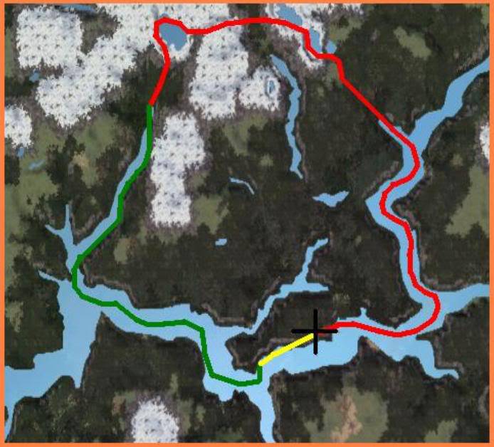
To start off with, place your aircraft at ENSG on runway six. I suggest taking a light aircraft like a Cessna 182. I took a Cessna 210 and it took me 30 minutes to complete the 105km circuit, cruising at 170 knots.
Set your weather to low visibility in the weather options (10-16km) but with no wind or rain or clouds. Set the time and date to lunch time on a summer day. Make sure you don’t do it on a winter day because otherwise there will be snow EVERYWHERE. If you do it on summer there’s a mix of everything, with calm blue waters in the fjords, steep rocky cliffs, rolling grassy pastures, tree-lined valleys, mountain lakes and snow capped peaks!
I haven’t posted any screenshots like I normally do because I don’t want to spoil the surprise for you. I thought it would be cool if you all took some screenshots and posted them here in this forum instead to compare with one another!
Anyway, take off from runway six, heading westwards, following the red line on the map. When the fjord shortly splits into three, take the left river, and follow it north at staying about 3,000 feet. After a bend in the river, you will see a tributary river splitting off to the left again. Turn up it and follow the small stream up into the mountains. You will see some lakes on a plateau with steep cliff edges around them. At the end of the second lake's cliff, turn west over it and head over a steep grassy valley until you reach another isolated lake. Once over that lake, turn southerly and head towards the inlet in front of you. Your altitude will have increased a lot once over these mountains so begin to descend until you are at just 1,000 feet. Fly fast and low along the cliff edges, getting as close as possible to them without crashing! (The whole area marked in green on the map above is the part of the route where you should fly low at 1,000 feet) Once the fjord widens, take the left split and head back towards 'Haukasen' there will be a big fjord off to your left which you need to ignore and continuee past before you see the land which you started from. The area marked in yellow on the map above is the most tricky park of the whole route and requires a certain amount of skill. As your turn around the outlet cliff head in front of the airport, your will need to CLIMB up 600 feet to get level with the ground above, then climb a little more, before DESCENDING again down onto the runway. You need to manage your speed and flaps carefully to make sure you don’t stall!
Have fun!
 7 Answers
 Jump to latest

 Captain
 First Officer


